Just another WordPress.com site

Archive for October, 2004

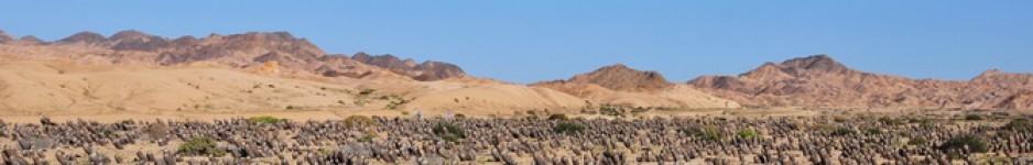
Thursday 14 October 2004 – Taltal: Quebrada San Ramon

I guess it had to happen. One of my favourite cactus spots on this planet, the Quebrada San Ramon, now has a public car park at its entrance. Well, it’s not quite that bad, the pending and expanding tourist trade in Taltal has given rise to some well prepared car parks with picnic and camping facilities. One of these spots is near the entrance to the quarry at the mouth of the Quebrada.

This was my fourth visit to this location and we agreed that we’d march some 7 km straight in, without too much stopping. This would get us to the point where Copiapoa krainziana and Copiapoa rupestris grow side by side.

During my second visit, in 2001, we saw C. krainziana growing along the western side of a quebrada that comes into San Ramon from the north, but these plants look quite different from that population. Here, the clumps have fewer heads, with longer stems. The spines here are extremely brittle and come off the plant at the slightest touch. As a result, the old stems look like ageing punk rockers, with just a tuft of white spines at the apex.   

The rain that we had experienced a week earlier had left damp patches along the valley floor. Annuals were starting to appear and shrubs were coming into leaf and flower.

It brought home the fact that I could spend a complete three week trip in the Quebrada and still not see ‘everything’ – to explore the side canyons and the hillsides. Even then, it would only be a three week snapshot in time – perhaps it would be better to make various visits during different months of the year to gain some appreciation of how the scenery changes during the seasons. But then, the local concept of seasons is quite different from what I’m used to in Europe, with its fairly regular and predictable four seasons per annual cycle. Sure, there seem to be similar seasons here, but they seem to be very similar. There is another, much more significant seasonal cycle that is influenced by the El Nino effect. I have now seen this Quebrada in May 2001, June 2003 and October 2004. It will take many more visits to gain even a basic appreciation. Perhaps I should move to Taltal ☺

The cameras were snapping all through the Quebrada and have been arranged into 5 stops:

  • S278 – at the mouth of the Quebrada,  nearest the Ocean, so with the first and last pictures of the day

  • S279 – from about the first 20% to 33% of the valley

  • S280 – roughly the second third into the valley

  • S281 – roughly the last third  – where C. krainziana grows

  • S282 – as far as we got today – stopped for lunch and then went back

As usual, we returned to the cabañas tired but satisfied with what we had seen and with the images that we had taken. Tomorrow we’d leave early to go to my other favourite Quebrada, at Botija..

s279_0037

S279: Variability and diversity are the key issue to resolve in Copiapoa taxonomy.
Here an offset of a C. cinerea fa. could (in splitter’s terms)
be considered to be a different taxon, based on its appearance.

Wednesday 13 October 2004 – Cerro Perales and Cifuncho again

Following our 2001 trip, Marlon Machado’s ‘Cacti above the clouds’ pictures, taken on the summit of Mt. Perales, rapidly became everyone’s favourite cactus picture. I always regretted that both my SLR cameras and my digital camera at the time were having minor problems, with batteries, film and memory running out on each, just as I wanted to capture the moment. By the time that they were all up and running again, the sun had burned away the clouds, so all I was left  with were pictures of nice cacti growing on a hill.

In 2003, I had really built this location up to my fellow travellers and was bitterly disappointed on the day that we were to repeat the experience, to wake up to a clear blue sky. We drove the tricky track to the top anyway and enjoyed the wonderful views over and beyond Taltal – a breath taking view in its own right. So, when the top of the Cerro Perales was veiled in clouds when we woke up this morning, things looked promising for a repeat of 2001.

As you drive from Ruta 5 into Taltal, there is now a sign post indicating the turning to Cerro Perales. Things seemed to get easier all the time – but ….. On previous occasions, after turning off the main road, we followed a track that ran parallel to the main road for a few km before heading up into the mountains. We did so again this time, but failed to recognise any landmarks. There were some large Copiapoa cinerea around, so we made a couple of stops (S267 & S268), as much to check GPS references as to  take some pictures and look for seed. I was worried though, that as time progressed, the clouds would evaporate, as they had done in 2001, before I had taken my pictures.

We went back to the point where the sign took us off the main road and this time did the obvious thing at the first crossroads (cross-track?), i.e. continue in the direction indicated by the earlier sign, instead of following the track alongside the main road. This proved the right thing to do – as soon the familiar sight of the small farm house with 3 palm trees appeared – the half way mark for our ascend.

And so we arrived at the summit. The clouds were still there and I wasted no time to get to the spots that I had selected on previous occasions. (S269) I can’t complain about the results, and yet, third time round, to my eyes they lack the impact that the wonder and surprise of the first visit added to Marlon’s pictures. 

As usual, we paused on the way down hill at a spot that probably best shows the track winding down the hillside, with the Quebrada Taltal and the Taltal to Ruta 5 road in the back ground. It  also has, to my mind, the finest stand of white-waxed, clean Copiapoa cinerea (S270).

It was still early, with plenty of time to have lunch in Taltal, followed with a trip along the coast road south to Cifuncho, to check up on the flower colour of C. desertorum – or should it be C.  rubriflora – at around 2 p.m. We made a few short stops:- S271 – with a few C. columna-alba; S272 near sign post to Las Guaneras – no cacti found; S273 – no cacti found and S274, marked on the map as Caleta San Pedro, where we found C. desertorum.

Then, the moment of truth, as we reached S275 – the same spot as S260, two days earlier. There were the plants, there were the flowers – as open as the spines were going to allow them to be, and despite being colour blind, I had to admit that these flowers were red enough to justify the name. Having taken all the pictures possible, we headed back to Taltal, only to be tempted to a sign to Las Tortolas. The track leads through a fairly wide Quebrada with a dense population of C. columna-alba. These reduce in number as the valley narrows, close to the coast. On reaching the coast, the track splits, one heading north, the other south. This is Caleta Tortolas (S276), and has been marked on the map for future exploration, as now, we had once again run out of time. We made one more stop on the way home (S277), among the C. columna-alba, more to get another GPS reading to plot on the map, rather than to explore and report on.

s275_0001

S275: But C. rubriflora is supposed to be synonymous with C. rupestris, not C. desertorum
OR There are red flowered forms of several taxa of Copiapoa.

Tuesday 12 October 2004 – Taltal – Paposo – Taltal

A quick rain and health check revealed that all was A OK. We decided to take a drive to Paposo, to see how the weather had affected things along the coast road. Another guest staying at the cabañas was Michael Dillon – amongst other things – a well known author of many papers about the South American flora, particularly of Chile and Peru and particularly on the vegetation of desert oases – lomas regions – and the plants in the genus Nolana. We had some correspondence in 2001 in advance of my first trip to Chile. Michael reported that there had been two short showers in Taltal during the previous couple of weeks – presumably those that we had witnessed. One had produced 20 mm of rain, the other 35 mm. However, without detailed rainfall statistics, I have no idea if this is usual or very rare – more things to look up when I get back home.

After getting our punctured tire fixed, we set off for Paposo and noticed the intensive work that was in progress to straighten, widen and surface the coast road – Ruta 1. As we drove past the entrance to the Quebrada San Ramon, scheduled for a visit in two days time, we noticed that the quarry at the Ocean end of the valley was back in use – the first time that I had seen activity here. It took exactly an hour to drive the 56 km to Paposo – a great improvement, despite some hold ups where diggers and trucks had been blocking the road as part of their activities.  But at what expense to the plants? In 2001 we had come across a large number of uprooted Copiapoa albispina / gigantea along the road. The plants had been tagged and treated with sulphur dust against rot. At first we thought we had stumbled on a commercial collector’s pick up point, but later Attila and Rudolf met a lady botanist, employed by the military, who also seemed to be responsible for the actual road building work. She explained that her task was to scout ahead of the road-crews and identify populations of plants that had to be moved and that would be replanted in a safe place.

In 2003, we found many of these plants replanted a little distance from the road. They had not appeared in top shape and obviously it would be difficult to provide the extra care required for a plant to re-establish itself in these harsh conditions. Some of the rescue plants from mining projects had found their way to the Cabañas Caleta Hueso, to the small garden belonging to the mine manager, next to Quebrada San Ramon and to the small botanic garden being constructed in Taltal. Here, with regular care, the plants would have a better chance, but with plants rescued from a large area now standing side by side in the open air, pollinators would soon ensure that some not-so-natural hybrids would result.

Our first stop (S261) was at the Paposo Cemetery, where the expression ‘Rest in Peace’ seems inappropriate – right next to the power station. There was evidence of some recent rain, with clumps of Copiapoa haseltoniana close to the track looking as if they had been placed in recently prepared cement that was still setting. Only time will tell if we should modify our soil tips for these plants in cultivation – the rain had been too recent to produce a reaction from the Copiapoa or from Eriosyce taltalensis ssp paucicostata or the Eulychnia.

Next stop was at the Virgen de la Puntila -‘ the Paposo Shrine’ (S262), on the road above the village that ultimately leads to Ruta 5. Again, things had changed, with a huge caterpillar (the digger, not the butterfly larva type) taking up the spot where in previous years we had parked our cars. The Copiapoa humilis and Eriosyce taltalensis here were in good shape.

The track leading to the fog zone above Paposo (S263), that is part of the Reserva Nacional Paposo, seemed to have suffered from rainfall since June 2003. It seemed as if water had washed away most of the sand, leaving large boulders to bounce the car off. Unlike 2003, the fog was out, with the cloud base around the tops of the electricity pylons that form a neat row up the 700 m. hill from the power station below at the cemetery. There is a plot of rescued Eulychnia iquiquensis along the edge of the hill and Euphorbia lactiflua was in full flower as was another yellow flowered non-succulent plant believed to be Balbisia peduncularis. The improved light conditions, compared to 2003, enabled me to get the digital images that were difficult to get last time round.
There was time to take a look at the high altitude Copiapoa cinerea from Paposo – C. eremophila, but once again, we just had enough time to look at the plants growing along the road to Ruta 5 (S264) – not the best looking plants, covered in cement-like dust. There were several lilies and other wild flowers that cheered up the otherwise grey hill side.

On the way to Paposo, we had noticed that the effort of straightening the coast road had involved ‘clearing’ some large rock formations, presumably with explosives. As a result, an entrance to a Quebrada had appeared that I can’t remember seeing on previous trip. We agreed to take a closer look (S265). There is no name on the topographical maps we have, so for now, I’ve called it ‘Quebrada Nova’. We walked into the Quebrada for about 45 minutes and found a range of Copiapoa cinerea, rather like in San Ramon, that  might be called C. haseltoniana or C. gigantea, depending on your taxonomic preferences. However, the range of variability was significantly less than that found at San Ramon.

Time was getting on and there was one more newly exposed Quebrada to take a look at, nearer Taltal. The time was now 5:30 p.m. and the light was not good for more photography, so we limited our efforts to taking a GPS reading that, according to the maps, corresponds to Quebrada del Hueso Parada (S266) (NOT Quebrada Hueso, near the cabañas where we were staying). This quebrada will have to wait until a future visit for a more detailed look.

s263_0041

S263: C. humilis, above Paposo.

Monday 11 October 2004 – Juan Lopez to Taltal

It was dry when we woke up. Great!

We looked out of the breakfast room and could see the beach – no fog. Great!

We looked up towards our goal of the day, the 1,148 m. high Morro Moreno, only to learn that today, the cloud base was at 50 m above our heads. Alain was doing his best to put a brave face on things. I had already dismissed a climb today, but wanted to at least have explored around the base of the Morro to look for a possible starting point for a climb to the top. Fortunately, various roads and tracks provided access to various tourist beaches, with dozens of tents perched along the ocean. We followed these round until the path became impassable (S258).

Later we learned that today (Monday 11 October) was a national bank holiday. I immediately understood the weather pattern – Spring Bank Holidays in the UK usually turn out to be wash-outs too.

We drove towards Antofagasta and saw a huge cloud at the Juan Lopez end of the Morro Moreno, and a thinner cloud hanging closely above the rest of the Morro. We took some pictures at La Portada, a rock formation just off the coast in the Pacific Ocean that was declared a National Monument in 1990. The only sensible thing to do was to use this wasted day as a travel day and to head south down Ruta 5, back to Taltal, in the hope that the weather down south had improved since our last brief stay. At about 3:15 p.m., Ruta 5 turned towards the coast near Taltal. A thick layer of clouds seemed to pour over the top, heading inland where it quickly evaporated.

By 3:40 we were admiring developments at Cifuncho, basking in the sun, to the south of the village, at Caleta de Afuera, where in 2003, we had found Rudolf’s ‘sp. Cifuncho’, probably the most northern form of Copiapoa longistaminea. There had not been many plants here in 2003, and signs of beach parties, motor bike scrambling and lots of broken glass raise concerns for the plants that are left. This time (S259) a number of plants seemed to have been up-rooted as part of a game and lay randomly strewn about, roots in the air. I replanted a few, against better judgement.

We went back to the spot where we had found Copiapoa desertorum and C. columna-alba in 2001 (S052)  and 2003 (S128). This time (S260) some of the C. desertorum plants were in flower – red! This answered a lot of my scepticism about the existence of C. rubriflora – here it was. And yet ….. it was late in the day, the low sun gave a reddish tinge to everything and I had seen yellow Copiapoa flowers turn reddish at the end of a long period of flowering in my collection. We took many pictures of many flowers on many plants. There would be time in our revised schedule to come back another day, around midday, for another look.
Excited and as the sun was setting, we took the new coast road to Taltal, booked back into the cabañas, hoping that the following morning we would wake up to the more customary sunshine.

Sunday 10 October 2004 – San Pedro de Atacama to Juan Lopez (Antofagasta)

And so, on ‘day 9 on-the-road’, of a 21 days on the road trip, we effectively started the ‘return home’. We enjoyed a full English breakfast and some sightseeing in San Pedro.

Our goals had included seeing C. tocopillana just south of Tocopilla and C. atacamensis on Morro Moreno, north of Antofagasta. Both involved extensive climbs, Alain was still feeling bad and Benjy’s detailed maps were still in the UK. Plus the weather at the coast, that had driven us north, was still an unknown factor.
Anne and I in particular were keen to have our picture taken at the airport of Maria Elena. A few years ago, a TV programme series called ‘Extremes’ had officially declared this to be the driest place on earth – i.e. the driest place where equipment was kept to measure such things and where official weather records were kept. From memory, the record of 0.04 mm average annual rainfall over a 30 year period was the result of one single brief shower during that period. We drove along Ruta 24 from Chuquicamata to Maria Elena (83 km) and, if we had bothered, could have counted the plants that we saw along the road on the fingers of our combined hands.

At Maria Elena, we found a sign and barrier across the track that allegedly led to the (disused?) airport (S257) and duly took each other’s picture. And because we’ll grow up one day, but not until many years in the future, Alain and I had to mark the spot in a way that proved that, at least at that time, it had not been the driest place on earth.

It was decision time – on to Tocopilla, or turn south to Antofagasta. We voted sensibly and unanimously for Antofagasta. After a long lonely drive through the desert, entering a major town (285,255 inhabitants) can be a little unsettling. We found a petrol station to top up, then headed north – west, to take a look at tomorrow’s challenge: the 1,148 m. high Morro Moreno. To give us a head start, we decided to spend the night in the small hamlet of Juan Lopez, at the foot of the Morro, rather than to drive the c. 30 km back into Antofagasta. Mistake. The single taps in the bath room were an indication that there was running water, that came in one form only – cold. The elderly couple and assistant that ran the place, and seemed omni present, seemed to share 3 teeth between them. There was no electricity, until night fall, when the generators started up all round the village. We were the only guests and the restaurant was not due to open until breakfast time. We found what seemed to be the only other open restaurant and found it crammed full of people, huddled around the television set. The owner was keen to make his foreign visitors welcome, told some of the locals to move and prepared a table and (as usual) excellent food for us, while we shared the disappointment with the other guests, at Chile’s 2-0 defeat at the hands of Ecuador.

Noises during the night indicated that Alain’s stomach was not responding to the usual medicines. Not a good omen for tomorrow’s planned adventure.

s257_0002
S257: The airport at Maria Elena – the driest place on earth.

Saturday 9 October 2004 – Around San Pedro de Atacama

There was some logic behind our non-cactus day, yesterday. We had rapidly climbed from sea level to around 2,500 meters in altitude. Before climbing to greater altitudes, to look at the local cactus flora, a day’s acclimatisation was no luxury, and arguably not enough.

Our first challenge was to find fuel for the Toyota in San Pedro. The map showed a fuel station in the town, but the one we had found in 2001 had been moved. Eventually, after driving several times around and through the village, as much by process of elimination as thanks to the directions from the local population (are there any native San Pedroans or are they all tourists?), we found the Copec station, hidden in a back street. We took a GPS reading so that we could find it again in future.

And so we set off in high spirits, on the unpaved B245 to El Tatio, only to be over taken by two cyclists as we experienced our one and only puncture (S252). The cyclists were a couple from Belgium who, some 10 km out of San Pedro, were hardly out of breath as I introduced them to the suffering Alain. After we had changed the wheel, we looked and photographed some of the large cushions of Opuntia / Tephrocactus / Cumulopuntia, depending on your taxonomic preference. As far as species are concerned, there are plenty of opportunities for splitters to give a different name to each of the huge range of spine colours. I’m happy with the common names ‘sleeping sheep’ or ‘mother-in-law’s seat’ for all of them. Some of the spines were around 11 cm (4 inches) long! We photographed even more of these cushions later (S256).

In 2001, we had found some Oreocereus (Arequipa) leuchotrichus (or variicolor?) along this track (S044) and with the aid of the GPS, we found the spot again (S253). The plants were still there and, once Anne and I had clambered down the steep gravely hill side (Alain, weak from his stomach bug and the effect of high altitude, stayed on the road), we found ripe fruits and flowers on some of the plants. The high altitude really did not encourage long walks to explore the extend of what seemed just a single, small group of plants. However, we returned to the car with plenty of pictures.

For the same reason, we were happy to wait until the Echinopsis (Trichocereus) atacamensis came to the road,  particularly when Anne spotted some in flower (S254 & S255), even though we had spotted them on distant hill sides for a while, like groups of telephone poles.

We passed the famous Hot Springs at Puritama, to cactus tourists no more than a puddle with small groups of fat naked tourists paying money to sit in muddy water. We did not stop, other than to check for Echinopsis (Lobivia) formosa (= Soehrensia uebelmannianus) that Graham Hole had reported from here on his 1999 trip with Walther Rausch and Franz Kuhass. Non were spotted here this time, but one was found on the way back (S256a), near to the Cuesta el Diablo – and in flower!

In addition to these cactus stops, we saw some breathtaking (due to the high altitude?) landscapes and some marvellous alpine grasses and miniatures that I still have to find names for – any assistance gratefully accepted.

s256_0056

S256: Pycnophyllum macropetalum, an Alpine member of the Caryophyllaceae,
the Carnation Family had us fooled into thinking that we had found
the first Chilean Anacampseros.

Friday 8 October 2004 – Calama to San Pedro de Atacama

Today was always going to be a general tourist day, rather than a plant-hunt day. By reaching Hotel El Mirador in Calama the previous evening, we had made up lost time. By leaving Calama soon after breakfast, we approached San Pedro de Atacama in good time and around 10 a.m. found ourselves driving through the Valle de la Luna – the Valley of the Moon (S249). These days, the proper tourist way to see this salt lake is by organised night time coach trip from San Pedro, to watch the impressive southern hemisphere sky at night, without clouds or light pollution, until the laser light show highlights the salt pillars that rise like statues out of the landscape. We were happy to use our imagination and later, were woken up by the other tourists’ 4:00 a.m. departure to this (nightly) event, or did they go to the other San Pedro classic – sun rise and break fast at the geysers of El Tatio?

We had succeeded in leaving the damp grey weather behind us and had to watch out for sunburn as we enjoyed hot spring weather at 2,500 – 3,800 meter (7,500 – 12,000 ft) altitude at approximately 22 degrees south of the equator.

We visited the remains of the Aldea de Tulor (S250), a small settlement based in the oasis-like locations that was populated between 800 BC and 500 AD. Next, we visited the small village of Tocomao (S251) – less commercial than San Pedro de Atacama – where I was able to get most of my souvenirs at less cost than in San Pedro. In one shop, where I bought Angie a scarf made of Alpaca wool, the owner was proud to take me to the small yard behind the shop, where kept the sheep and the small llama (alpaca) that provided the wool for her art work.

We tried to find a flamingo or two in some of the numerous areas shown on the map as belonging to the Reserva Nacional Los Flamencos in and around the huge area of Salar de Atacama – the Atacama Salt Lake. We found neither water nor flamingos. Next time we’ll do some research in advance as I presume their presence is seasonal and we were there at the wrong time. Talking to other tourists later who had taken guided tours to the lagoons, we learned that the coach took them to one lake with some 8 birds in total – hardly the thousands of birds that pictures lead one to believe.

So, a day without cacti! Well not really, many of the restaurants, shops and churches have bits made out of cactus wood – Echinopsis (Trichocereus) atacamensis and we did see a couple of miserable looking specimens in the plaza at Tocomao and a slightly healthier one in a private garden, as we left the village.

We’d make up for it tomorrow.

Thursday 7 October 2004 – Taltal to Calama

The surprise, to wake up to the sound of rain on the cabaña roof, was not so great this time. In Europe, we’re well used to days-on-end of rain.  The advantage of a plan, prepared in great detail during the previous nine months, is that you can ignore it on arrival, or, when conditions or events indicate, that you can shuffle dates and places around to suit.

We did some sight seeing in Taltal and noticed the progress that had been made at pace, with new schools, housing and roads and major road improvements to Av. Arturo Pratt in progress. The town is also proud of its ancestry, with it’s museum and tribute to the railway system (Plaza del Tren) and recognises the need to entertain the population and tourists alike by having created a mini golf course and outdoor sport facilities near by and is even in the process of creating a small botanic garden (S246) to display the wealth of cacti that occur between Paposo and Cifuncho.

But the weather showed little sign of improving, and so we decided to head north, reaching Ruta 5 in low cloud, with puddles of water on the road and the windscreen wipers going.   Soon however, the sky brightened slightly and the fog turned to steam coming off the tarmac. We made good progress and stopped off for a bite to eat in one of the many truck stops along Ruta 5.

We pushed on, reaching the impressive, but graffiti covered Mano del Desierto, (S247) a massive sculpture of a hand rising out of the desert, some 70 km south of Antofagasta. No plants here, but my stop numbers are designed to help me to retrieve digital images, they are not Field Collection Reference numbers.
The only other stop of the day (S248) was an un-manned railway crossing on Ruta 5, just south of Baquedano. Throughout Chile, motor drivers slow down religiously, as signs warn of a railway crossing further down the road. Signs warn road users to stop (and presumably look and listen) for any approaching train that – by virtue of its size – has (takes) priority.   At many of these crossings, no train has passed for years, the rails having been removed a long time ago.  And yet, cars, busses and lorries slow down, almost as a tribute to the past days of steam. In 2001 I had been told of police traps at these crossings, with drivers fined significant sums for not stopping at  locations where the line was no longer in use. I do not know how true the stories are – I never saw any evidence of police near these crossings. Yet it is curious to have unmanned railway crossings (here with the line in use!) on the Pan Americana, mile for mile the busiest road in the country.  The pictures taken illustrate why it is good to stop where the signs suggest.

That night we reached Calama and found comfortable accommodation at Hotel El Mirador, where we enjoyed a few glasses of Chilean wine with some fellow tourists from Alaska, whose main interests were the Chilean wine offerings, but who had just been to our next target, San Pedro de Atacama, for a no-vineyard break.

Wednesday 6 October 2004 – ‘Secret Valley’ to Taltal

The last thing I would have expected happened as I woke up, at around 6 a.m. There was a strange, yet familiar, noise on the tent – RAIN! in Secret Valley! (S237) It was still raining – well, something between a light rain and heavy drizzle really – at 7:30 when a call of nature forced me to get up. Everything looked very different wet – amazing! I wonder when these hills and plants had last seen rain like this.

The drizzle also dampened our enthusiasm. We packed the wet tents and by 8:15 we were back in the Guanillos Valley (S238) for a second attempt to find Copiapoa laui at the familiar location where we had found it abundantly in 2001 and 2003. Again, Anne and I felt sure that we had the right place, confirmed by the GPS reading. Oxalis gigantea was still in flower but already coming into leaf – usually regarded as an indication that there had been some moisture a few days earlier. After an hour of searching, we finally had to admit that the plants had either gone, or, more likely, had become invisible. Perhaps they had become extremely shrunk and shrivelled after a long period of drought and were still waking up from the drought induced dormancy. I bet that as I write this report, the plants have swollen significantly and are either in bud or in flower. Graham Charles and Roger Ferryman are due to visit this area with members of the CaSS(US), and it will be interesting to hear / read what they found.

Next on the agenda was a drive through the Tigrillo Valley and a visit (S239) to the C. longistaminea that grow between the magnificent rocks, close to the Pacific Ocean. These rocks – a very course granite – have been weathered, probably blasted by sand storms and (some) water over many thousands of years.   
From here, we drove back inland, turned north and then west again, with a quick stop to take more pictures of the seemingly endless stand of Copiapoa columna-alba (S240) and back to the coast at Caleta La Madera (S241). It is strange how in the Tigrillo and La Madera Valleys, C. columna-alba are the dominant plants inland, with C. longistaminea as the dominant plant ‘on the beach’. Yet in the Guanillos Valley, C. longistaminea and C. grandiflora are the visually dominant Copiapao and further inland, at Secret Valley, C. columna-alba and C. longistaminea grow side by side. From time to time, both have been regarded as belonging to the Cinerea complex in the genus Copiapoa – with a fibrous root system rather than a thick tap root and (under favourable growing conditions) with a white waxed epidermis. I understand that it is unusual for closely related species to grow together without the occurrence of intermediate forms – natural hybrids. I do not recall having seen any or reading reports from others on this point – providing professional taxonomists with a bit of a head ache.

So far, we were covering the same territory as in 2003, but I was keen to extend the search farther north. Again we drove inland and north, again we met the endless stands of C. columna-alba, (S242), like pavements full of shoppers heading north. Again we turned west (S243), through a valley (Quebrada de Leoncito) still surrounded by C. columna-alba that thinned out as we finally reached the Ocean, through a narrow gorge. At the gorge (S244 & S245) we again found forms of C. longistaminea, but each time that this plant appears along the coast, there seems to be a distinct local form for each Quebrada. Knize had used the name (nomen nudum) Copiapoa tigrillensis for the plants at the mouth of the Quebrada Tigrillo.  In ‘Copiapoa in their environment’, Attila Kapitany and Rudolf Schulz mention Copiapoa sp. ‘Cifuncho’, that we visited in 2003 and that I believe to be the most northern form of this species.  We’d return to it again later on in the trip (11 October).

The weather had not really cleared up and we decided to head for the Cabañas at Caleta Hueso, our home in 2001 and 2003, just north of Taltal – happy that I had another Quebrada form of C. longistaminea to add to my list. So how many more should I schedule for future trips?  Well, the topographical maps indicate:

  •    Bahia Ballenita

  •    Punta Lavata

  •    Caleta de Afuera (the location of ‘sp. Cifuncho’)

as the only named features before reaching Cifuncho. And with that thought in mind, I nodded off.

s244_024

S244: Are these mainly single headed plants still C. longistaminea,
or C. taltalensis / rupstris or an intermediate?

Tuesday 5 October 2004 – Chañaral to ‘Secret Valley’

There are several ways to get to (not so) ‘Secret Valley’ – a small Quebrada near Esmeralda, first used as a campsite by Attila Kapitany and Rudolf Schulz in 1994. It is marked with a GPS reference in their book ‘Copiapoa in their environment’. From Chañaral, the fastest route to this spot would be along the Pan Americana, until a turning onto a track due west.  But this would have taken us past several earlier turnings, sign posted for Parque Nacional Pan de Azucar and leading to a range of interesting Copiapoa taxa – hardly fair to Alain on his first trip out here.

And so we approached the usual (main) southern entrance of the National Park and stopped (S227) where some nice clumps of Copiapoa cinerascens grew on dark rocks, with the blue Pacific Ocean in the back ground – an ideal photo opportunity. The roads – yes, the term ‘track’ is no longer appropriate for these tarmac roads, with signs warning of dangerous bends and safety rails that prevent speeding motorists from taking a dip into the ocean – had been improved beyond recognition since June 2003. Great, as we were in a hurry, but a shame as the sense of exploration and adventure from previous trips became a fading memory.
We stopped (S228) at a site where in 2001 we had found a very healthy population (many plants of various ages, including small seedlings) of Copiapoa columna-alba, and were happy to find the plants in good shape.

On both previous trips, we had followed signs to El Mirador, but, soon after the sign post, had found a chain across the track, with a small car park near by, so that we had never travelled beyond this point. This time the chain was gone and we followed the track to a magnificent view point (S229) over the Pacific Ocean shoreline, from the sugar-loaf shaped island that gives the park its name, in the south, to the heights of Las Lomitas to the north. Huge shrubs of Euphorbia lactiflua were covered in flowers, while tall stands of Eulychnia breviflora (was E. saint-pieana) were in (very woolly) bud. The clumps of Copiapoa grandiflora looked less happy, as it seemed that tourists enjoying the views were in the habit of standing on the clumps. We also photographed an interesting Oxalis with relatively large flowers, compared with the weed that plagues UK cactus collections.

As we drove on, Anne and I recalled a spot where in 2003, Cliff Thompson, driving the lead car, had screeched to a halt as he had spotted a sizeable Eriosyce rodentiophila (E. megacarpa) in an otherwise lifeless landscape. We had recorded a GPS reading for the spot so I switched on the machine and we spotted the plant as the reading on the apparatus clicked to the reading taken 16 months earlier. Despite a more thorough look around this time, it remained the only cactus found here (S230).

The foxes at Las Lomitas (S231), a main attraction during previous visits, were out (gone shopping for more cream crackers?). The cloud (camanchaca) that is responsible for creating this fog-oasis in the desert, was just over our heads, offering us a rare view some 1,000 m. down to the beach below. It did not last long, and as the cloud base lowered on us, a curious guanaco came to take a brief look, having its picture taken before disappearing into the clouds.
We followed the track north along the cliff’s edge, careful as the track approached the crests of hills, where we were unable to observe its progress beyond the crest – in case it lead straight over the edge to the beach below (one kilometre!), until we reached the point (S232) where in 2003 I had dropped of a group of fellow Copiapoathoners for their walk down the hill to Esmeralda. A cold wind blew along the cliff’s edge and we did not stay long.

As we descended down a track (the tarmac roads from the south side of the park were long gone!) and stopped (S233) to take pictures of the very heavy spined Copiapoa columna-alba (is this what Ritter called C. melanohistrix?) with stems measured by Alain up to 105 cm tall. As we reached the level ground of the Quebrada de la Cachina, we made another stop (S234) at a densely populated plateau of C. columna-alba, before driving through the Quebrada Guanillos to pay our respects to Alan Craig (S235). On the way back, we stopped (S236) at the place where in 2001 and 2003 we had found the minute Copiapoa laui in large numbers, but in the failing light, failed to find any. We’d take a better look tomorrow.

Then it was off to Secret Valley (S237) to put up our tents, build a camp fire from dead Eulychnia saint-pieana wood and consume suitable quantities of Chilean wine to brave a night on the hard desert floor.

We’d have a big surprise on waking up the following morning……