I said yesterday that it was difficult to imagine how things could get better and today proved that I was right. It was not that we had a bad day, just that it paled into insignificance when compared to the previous few days. We had high expectations, as on the map, both the Quebrada del Toro and the Valle de Calchaquies run south east and south of San Antonio de Los Cobres respectively. They would appear to go through very similar geography and therefore we were looking forward to finding similar plants to yesterday, but in a different setting. The first difference was that instead of going down from San Antonio d.l.C, we went up. The second was that soon after turning on to the Cachi road, the quality of the dirt went the opposite direction: down. So our average speed was around 20 km.p.h., or 10, if you took account of the stops for scenery and cacti.
One thing we wanted to check was the maximum altitude where we find cacti. The other was to put some cactus locations on the map, as every one seems to shoot up and down the famous Quebrada del Toro, while we struggled to find any stops in our database along this route. The poor quality of the track was one obvious reason. We were advised to check that the road was open with the police at the check point into town. They had not a clue. We were advised to travel at least as a two car group. We had met a couple of Germans who were going the same way, but they had a slow puncture when they looked at their car in the morning so wanted to get that fixed first. We did not want to hang around, so left on our own. The track goes over what is reported to be the highest pass in Argentina at close to 5,000 m. above sea level. We were now well in tune with high altitude and did not particularly suffer any problems accept getting out of breath quickly, but even that was improving surprisingly well.
I managed to take 261 images at 9 stops, but, as I was driving, only 1 movie clip. But many of the images were taken as a record of what we found at each location, rather than to add to the already alarming number of candidates for inclusion in talks, articles etc.
We left Hosteria de las Nubes at 3,774 m altitude around 9:48 after a quick email check. By 10:28, we made our first stop, S1083 at 4,168 m, in brilliant sun shine and those nice fluffy Andean clouds in the sky. Unfortunately there were only opuntioids: Maihueniopsis glomerata (must look up how this differs from M. hypogaea.) When we moved on again, I kept taking occasional pictures as Cliff & Juan kept spotting more opuntioids, higher and higher, recording their altitude with the camera’s GPS.
At 4,368, Juan spotted a Echinopsis (Lobivia) formosa along the road, half hidden under a shrub. Nice spot, Juan! (S1084). It was the only one we found, but due to the altitude, we did not search too far from the car. M. glomerata, C. boliviana and Tunilla sp were also spotted. By 4,476 m, the cacti were gone.
S1085 was a stop for a group of Condors circling around over the track. As we got closer, we noticed the carcass of a vicuna or guanaco (it’s hard enough to tell them apart when they are alive), with some hawks actually bopping on and off the carcass, as though it was their kill. I’m sure Mike can put me right on the Hawk ID.
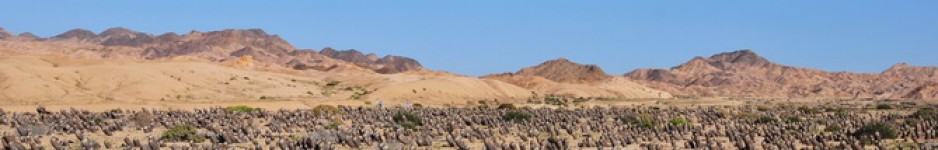
S1086 is just a series of scenic shots, including some at the highest pint of this track. The sign claimed we were at 4,895 m while both my and Juan’s GPS claimed that we were at 4,963 m.
From Wikipedia: The abra del Acay may be the world’s highest point over a National Route. It is in La Poma Departament, in the Salta Province, Argentina; around 30 km southeast from San Antonio de los Cobres. Its geographical coordinates are 24°23′S 66°14′W / 24.383°S 66.233°W / -24.383; -66.233 Coordinates: 24°23′S 66°14′W / 24.383°S 66.233°W / -24.383; -66.233, and its altitude (measured by GPS) is 5061 m, even though an old sign informs visitors it stands at 4895 m.
The abra del Acay was inaugurated on 1960-07-08, after three years of construction.
This unpaved part of the National Route 40 is only suitable for all terrain vehicles, with the exception of some months in the year when meteorological and maintenance conditions allow normal vehicles to transit. The road inclination of 4.5 % and the oxygen reduction due to altitude make the crossing difficult for both vehicles and humans.
Retrieved from “http://en.wikipedia.org/wiki/Abra_del_Acay”
Whatever, it was cold and we rushed to take a group photo, that included the car, now a beloved member of the team. Juan also spotted a small plant in flower that he identified as a sp. of Viola. I’ll ask Roger Ferryman to ID it. I carried on using this stop number until we spotted the first cactus, C. boliviana, at 4,483, just 107 m higher than on the other side of the pass. Remarkable. I wonder what the highest cactus recorded in nature is and at what altitude. Our data base shows 4,899 m for an Opuntis sp. from Abra Lizoite 50 km east of Yavi, so I’ll have to check my GPS data for stops around Yavi on 17th, and check the height claimed for the GPS coordinates in Google Earth for the location in the data base. The database selection was for Argentina only, so expect higher values when we do a global search!
Just before La Quesera the track crossed a stream that we had been following from the highest point. As I slowed down to avoid making a big splash, Juan spotted another E. formosa from the car, so a good excuse for a short stop (S1087). It was one of only two found. But there was a nice clump of Tunilla with 10 flowers, right along the road as well. And C. boliviana. A bit farther along the track, across the water, there were more E. formosa, not huge as we have seen elsewhere in 2005 and in Chile and across the stream, too far to get to, but close enough for some telephoto zoom pics.
At 3,565 m altitude (S1088) E. pasacana was back on the scene. But not weighed down by Tillandsia etc as in the Quebrada del Toro. All the flora indications were that this valley was a lot drier, both in terms of rain and relative humidity than the Querada del Toro.
S1089 was made because I needed a stop and had spotted a globular cactus that I thought was a Parodia as we drove by it. It turned out to be an Echinopsis, probably a form of E. (Acanthocalycium) thionantha, and there were lots of them, some in bud, others with spent flowers, but none actually in flower. The other globular cactus here was Gymnocalycium spegazzini, known as ‘spegs’ from now on. Here it was not the super spiny form called fa. major, but its spination was pretty good and a number of plants looked very good in any collection or show, but best in nature, or as a digital image to share with friends at talks etc. in time to come. Other cacti present were C. boliviana plus several other opuntioids, many in flower, such as Tunilla sp., E (Trichocereus) atacamensis spp. pasacana.
S1090 was a stop on land similar to S1089, to establish the range of the cacti that we had seen. Again, the E. thionantha (?) was the dominant plant, closely followed by G. spegazzini, the latter often hidden in dense acacia and palo verde shrub, or growing in the open, flat to the ground, almost covered in grit and twigs. Eagle eyed Juan found two plants that were ‘different’, one an Echinopsis sp. and the other ‘like a Thelocephala with some 8 long hooked spines’, with most of the body hidden below ground. The main difference on this site was that all the opuntioids were missing.
S1091 again extended our knowledge of the two main cacti, but here Opuntia sulphurea, in full flower, was more abundant and there were some more E. pasacana around too.
And so on to Cachi, or as Cliff is fed up hearing: ‘Cacti with an h’, where we are staying in the Hosteria, as in 2005. It has now got wifi, if you are wiling to sit outside the dining room, in reception and are not afraid to unplug the Christmas decorations so that your laptop gets enough juice.

Leave a comment