Friday 12 February, 2010 – around Baracoa
Today started around 7:10 with a light earth quake, or perhaps tremour would be a better description.
Mike’s stomach was having an off day, so after breakfast it was just Cliff & I who set off to find the way from the north to Punta de Maisi which is about as far east as you can go on Cuba. It is also about as far north as the populations of M. harlowii get, again hugging the coast line and the coral limestone.
Maps seemed a bit vague as to whether there was a road/ track between Baracoa and Punta de Maisi. There was a large sign on the road into Baracoa to mark the turn off to Punta de Maisi. The asphalt topped road seemed to justify its place on any map of the area, but petered out before too long into a dirt track with ‘guess-where-now’ turnings. For the next two hours we zig-zagged along good dirt tracks through densely forested hillsides. This area was still well populated with people walking along the track and we came across the occasional (1940s?) Willys jeep loaded with about a dozen people. A few times we asked confirmation that we were on the right track and indeed we were.
We made a stop (S1704) for a Rhipsalis hanging from one of the many Tillandsia covered trees.
Eventually we were surprised to hit a reasonably main asphalt road. It seemed that we had hit the southern coast road that, although not shown on the map, runs as far as Maisi. The elderly lady, waiting at the bus stop when we asked her for directions, assumed that her reward was a free lift – and why not. When we dropped her off in the village, she told us to turn right at the next junction to get to the lighthouse at the Punta.
I remembered the Spanish for lighthouse, ‘faro’ from our visit to Chile last year, where a rare subspecies of Eriosyce grows near a lighthouse, and the sign pointing to it at a fork in the road therefore made sense. Once there, we could see the cacti from the car (S1705).
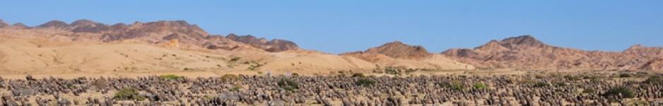
Again, Stenocereus fimbriatus (s.n. Ritterocereus hystrix) and Pilosocereus brooksianus were ever present, also used in fences all along the southern coast and Opuntia stricta (s.n. O. dilleni) was here as well. The coral limestone rocks were covered by a very thick version of the ‘shrub-with-glochids’, only some 5 cm tall and easily used as carpet, with the ‘glochids’ becoming attached as you tried to lay on the ground to take a low angle view of the Melocactus growing between them.
This was again M. harlowii ‘accunae’. No fruits were found to confirm the colour of the berries but the flower colour – pink – was as expected.
We made one more stop (S1706) before Punta Caleta, as the road dropped from the hills down to the Caribbean shore. There, on the roadside cutting all the cacti seen already, put in another appearance.
At Cajobabo we turned north, now back on the road to Bacarao that we took through the mountains yesterday. We’ll be coming down this route again tomorrow, as, having reached the farthest point east on the island, there is only one way to go: back.
We made no tight, rigid travel schedule for this trip as information was a little vague. We made it a priority to head for the densest and most varied cactus populations in the arid south east first and found it easier than expected. We have now seen these and only used up 10 days of our 28 day time budget, so there is plenty of time to look up some of the small and more remote cactus spots reported in the ‘Melocactus of Cuba’ book and to visit some places better known for their bird life, one of Mike’s other passions, rather than for their cacti.
