Just another WordPress.com site

Archive for March, 2011

Tuesday, 8 March, 2011 – Ciudad San Luis Potosi to San Luis La Paz

We had expected to reach our ‘farthest away from Bellflower’ goal today, but Eunice had a locations for various Echeveria on another road, to the south east rather than south of the city of San Luis Potosi. After a few wrong turns, we drove past the village of Villa Zaragoza where soon the asphalt changed to ‘graded chalk’. The track was heavily used by trucks – one every couple of minutes – driving to and fro from a quarry belonging to MexChem. Most of the plants were covered by a thick layer of cement like dust, as were we after a while. S2300 was for a number of short stops taken along the track, with many of the plants growing in or on top of the dry stone wall alongside the road and others a few meters from the road. It seemed that one pick up’s driver was quite intimidated by me walking along the road with a Nikon D300 with 200 mm zoom lens at my hip. He seemed a lot more comfortable when I brought the camera up to my eye to take some pictures. It seems that brown trousers are quite fashionable. A Mexican who had watched the whole event came over and asked if we were interested in plants. Yes we are. He gave us lots of tips of where to look in the area – if only we coud have understood more of what he had said. His name was Oscar and if our Spanish is correct, he told us that he has posted pictures on Google Earth.

We probably saw: Agave sp., Cylindropuntia sp., Echeveria agavoides, E. lilacina, E. potosoni, Ferocactus echidne, Mammillaria formosa ssp chionocephala, M. lloydii and two more Mam. sp., Myrtillocactus geomatrizans, Opuntia sp., Pachycereus marginatus, Senecio (Pittocaulon) praecox, a paculiar plant with seemingly woody stems and a yellow inflorescence on top – no sign of leaves, Thelocactus macdowellii (?), Tillandsia recurvata and a tree like Yucca sp..

It was interesting to see how we seemed to be meeting the onset of Spring as it travels north. Yesterday’s Echinocereus in flower was probably the first sign, with the Opuntias seen flowering today and many more shrubs and trees in flower being the other signs. Of course, they may just have had more rain more recently.

San Luis La Paz is one of the larger towns that we have visited that has maintained typically Mexican. That means that the choice of Hotels is somewhat limited. We are staying in Hotel San Luis which at Mex$ 375 for a double room with separate beds was a few pesos cheaper than at Hotel Parras next door (M$ 425). Both have wifi. As you enter the town from Hwy 57, drive past the bus station and enter Calle Rayon in front of you. The hotels are side by side on your right, eventually.

For food, restaurant West was recommended but closed, but Restaurant Las Islas was fine with excellent rib-eye steak.

Monday, 7 March, 2011 – Matehuala to Ciudad San Luis Potosi

We were late leaving Matehualla, due to Eunice not feeling well. A glass of Apple cider vinegar (yuch!!!) put her right again. We decided to make our first stop a localish one to see how things settled down. We were at a location for Turbinicarpus macrochele, but again the Turbs keep eluding us. We did find a dozen or more Lophophora, to prove that our eyes and noses were working. Also found Coryphantha sp, Sclerocactus uncinatus, Echinocereus pentalophus and Agave lechuguilla and probably A. americana. So not a bad spot.

This (S2298) was a JM (John Miller) stop, but again from some 10 years ago; proof that a lot can happen in the mean time. The locality looked identical to that in the Turbinicarpus of SLP book. Normally with a JM stop you can walk to the coordinates in blind faith that the plants are there, fall to your knees to give thanks while taking its picture at the same time. Not here. We had set a time limit – as you can easily spend a week here and not find the plants even if they were there.

As we drove off, we considered what to do next. I was mindful that we were half way through this trip and had not yet gotten to our turn around point. So we agreed to head south along Hwy 57, to San Luis Potosi.

The two Google Earth images show part of our problems that we have had since getting into Mexico. Image 1 shows the 200 km stretch between Matehualla and SLP.

Matehualla to SLP

At an average of 60 mph this was a two-hour journey. Should we make some more stops? Was there anything interesting along the way? Where? The next image, covering the same area, shows the locations that we passed. We could have taken a week to cover the distance and still not have seen the majority of cactus taxa in the database. In addition, Eunice has location data on Agave and Crassulaceae inthe same area – but there was no room on the map to show them! 

Matehualla to SLP

We made one more stop, at Nuñez, using Eunice’s information for an Echeveria.

On the hills on the other side of the highway were a handful of coordinates for Ariocarpus bravoanus. If they were across the road, they would probably be on our side as well. We drove around the small village’s dirt track to find a way up into the hill and in the end met up with some ladies pushing a cart up the track. ‘How do we get to the Camino Blanco?’ we asked, feeling quite chuffed with ourselves, to ask the way in Spanish. We were less prepared for the avalanche of Spanish that came back but understood that we had to drive along the highway (opposite direction, on a dirt track), then turn through a white gate (they caught up with us at the gate and let us through) and into the mountains. The track seemed to go round the hill rather than up it, so some 400m from the coordinates. We parked the car (S2299) and Eunice walked up, while I had a look around nearer the car.

My search produced Echinocereus pectinatus? rigidissimus? some in flower, most in bud; Ferocactus pilosus, some over 2 m. tall and also in bud and flower, lots of Echinocactus platyacanthus – one almost as tall as my 1.92 m (6 ft 4″) frame and at least 4 times my girth – huge. The question of age again went through my mind. There was also a Mammilaria that I’ll need to find a name for.

Then the horrible drive through Ciudad San Luis Potosi (almost 1 million inhabitants) in rush hour! Well done, Eunice! Found accommodation – again very comfortable – at the Holiday Inn Express, on the main road out south. Tomorrow we should reach our final destination – accommodation wise, then try to find Turbinicarpus alonsoi, either tomorrow as well or the day after. Fingers crossed after our (bad) luck so far with Turbs. Can’t grumble on the other cacti front though, as you can see below.


Sunday, 6 March, 2011 – South of Matehuala

I forgot to mention that yesterday we spotted clouds building up over the mountains and that during the drive home we actually had rain. Just a few drops but with incredibly threatening skies creating some very photogenic scenery. Back in the hotel it poured down, so that this morning, Ruby (our name for our current rent a car) was almost clean. Close inspection indicated that the cement like dust that we had picked up in recent weeks and that was still present in nooks and crannies had set as cement, creating wonderful screechy effects when we opened and closed windows. 

We thought that this was going to be a really easy day. The cactus data imported to Google Earth suggested that south of Matehuala we only needed to step out of the car to trip over Ariocarpus retusus / bravoanus / hintonii etc, together with a range of Turbinicarpi.

We asked our waiter over breakfast if the weather was going to clear up – it was still quite overcast. ‘I hope not, that was the first rain we had for six months! We need a lot more!’ It cleared up, great for our cameras, but it helped to explain why we struggled to find just a dozen or so Ariocarpus at only one of the five stops made today. And it was at the very moment that I suggested that we call it a day and go and get drunk at the hotel, that I found the first of these plants – tiny, only slightly larger than my thumbnail.

Sign posts indicate that the Mexicans regard this area as their altiplano – a high plain between the Sierra Madre Oriental and the Sierra Madre Occidental in the west. So far, I had always associated Ariocarpus with rocky lime stone hills, with the exception of A. kotschoubeyanus that we found last year on flats that during the rainy season turn briefly into marsh land.

Here, the SatNav took us to villages with flat scrubby terrain, divided into agricultural parcels, some freshly ploughed, others waiting to be prepared while still others were left to nature to do its thing. Ruby with its US (New Mexico!) plates and Eunice and I blended in with the natives like Eskimos in the desert!  At one stop, the same car passed by several times, curious to see what was going on. At another, Eunice actually found one tiny A. bravoanus ssp. hintoni, but then felt threatened by three kids in their late teens who had followed her up the hill. Looking at John Miller’s Living Rocks of Mexico website, they visited this area in the autumn of 2000,  now 11 years ago. All plants they saw were in flower and the scenery shots show a lush green landscape. Great, but the way we saw it today is probably the way that the plants look most of the time.

The successful stop was S2297. The SatNav took us to within 750 m of the reported coordinates of the Ariocarpus. Then the track ran out and we continued on foot. The terrain really did not seem conducive to Ariocarpus growing here. The sun was back out in force and the temperature was certainly not conducive to long hikes. Mad dogs and Englishmen …..

One cactus that we encountered more often than we wanted was the stick cholla (is it still Cylindropuntia leptocaulis here?) that insisted on stapling my trousers to my legs when ever I saw it. Even if I thought that I’d be kind and take some ‘for the record’ pictures, I’d back into one of its cousins behind me.

When we reached the coordinates there was not a cactus within 20 yards, certainly not an Ariocarpus. So we switched to instinct and experience. Another 200 m. on the flat terrain gently dropped away giving us a good view of Hwy 57 in the distance. A slight breeze picked up, as is often the case around hillsides. I could hear Juan say: ‘Here is where Thelocephala might grow.’ and I could imagine the Camanchaca crawling up the hill. Of course there was no Ocean near by. There was a narrow band of a slate like stone that had been pushed up vertically – a bit like the Yava cryptacarpa habitat, also a good few hundred km away from an Ocean. I took a picture of a shrivelled up Thelocactus sp. and suggested that we had given it our best shot, when I noticed the Ario – much smaller than I expected and of course with measuring implements safely in the car, so my finger had to do. We looked at this ledge in quite some detail for the next 30 minutes or so and found some 12 tiny plants in total. This ledge extended for quite a distance, we could see a huge white cross on a hill that was the suggested location for an earlier stop, some 20 km away, and I would not be surprised if the plants would occur continuous for all that distance. At the cross Eunice had found one plant before feeling uncomfortable with the attentions from Mexican lads.

Another set of coordinates would now seem to be underneath the foundations of a nice bungalow. That’s progress.

Throughout the day and at all stops (S2293 to S2297) we also saw many large Ferocactus pilosus, in bud or early flower, Echinocactus platyacanthus, Cylindropuntia tunicata, Opuntia sp. Agave lechuguilla, Opuntia and Cylindropuntia sp (several of each) and very dry clumps of what could either be a Thelocactus or Echinocereus – too dry to give a positive ID plus some plants of what I’ve been calling Ferocactus hamatacanthus, but when I saw some in flower, I’m inclined to call them Sclerocactus (Glandulicactus) uncinatus. We saw a total of four large clumps of Mammillaria in excellent shape – could be M. compressa or one of its look-a-likes. In the villages, Pachycereus marginatus was the standard fencing and it was in flower as a bonus!

Tomorrow it’s time to move on, with so many locations on Google Earth still tempting us to stay. As Arnie said: ‘I’ll be back!’ 


Saturday, 5 March, 2011 – Matehuala to Zaragosa and back

Where did we want to go today?

A simple enough question, but when you are surrounded by locations that contain more Connoisseur Cacti than your average nursery, the question is not so easily answered. Eunice wanted to go to Zaragosa so I suggested the first location from the database on the road from Matehuala to Zaragosa. As it was, we missed the turning and so missed Turbinicarpus macrochele, but got the next turning spot on and stopped at a natural car park at the bottom of a low hill – the kind of location that you could find all over this area, but this one had been explored before and on that occasion had rewarded the explorers with Pelecyphora (Encephalocactus) strobiliformis. I’d put money on that species occurring on every low hill in sight, but time was too short (again) to check that out.

I noted S2288 as the next available stop number and by the time we got back to the car had added the following to my plant list: Agave asperrima (s.n. A. scabra), A. lechuguilla, A. stricta, Ariocarpus retusus – just one plant spotted, but again, they seem to be on every hill side – Cylindropuntia sp., Dasylirion longissimum (s.n. D. quadrangulatum), Echinocactus platyacanthus, Euphorbia misera, Mammillaria formosa ssp chionocephala, Neolloydia conoidia, Opuntia sp., yes!: Pelecyphora strobiliformis, Stenocactus sp., Thelocactus hexaedrophorus and Yucca faxoniana (s.n. Y. carnerosana). There was probably also a Coryphantha sp or was it another Thelocactus sp. here? The pictures below are all from this stop.


This trip is as much an expedition to get to know the roads and facilities offered by the various towns and villages as a search for cacti and other succulents. Using locations reported by other cactus explorers helps to recognise what grows where without losing too much time, while the ad-hoc leg stretch and toilet stops rarely fail to surprise us with things not previously reported.

The towns & villages objective took us to Dr. Arroyo (S2889),  La Escondida, Aramberri (S2891) and Zaragosa (S2892) during which I added Pachycereus marginatus and Dasylirion berlandieri (The ‘Zaragosa Blue Twister’) to my plant list.

The ad-hoc leg stretch stop (S2890) was prompted by Eunice spotting a large Ferocactus pilosus along the road and suggesting that our friend Alain Buffel from Ostend, Belgium, would feel better during these hard winter days in Europe by seeing a picture of this plant taken by Eunice’s cell phone and sent as soon as she had a phone signal. Miracles of modern technology.  I’ll hold fire on the plants found here, other than to say that I saw Echinocereus pentalophus for the first time in nature. For many of the other plants I struggle to even name the genus!

Friday, 4 March, 2011 – Galeana (NL) to Matehuila (San Luis Potosi)

Yesterday we had solved the puzzle of how to get to Geohintonia mexicana and Aztekium hintonii, at least in theory. We returned full of confidence and continued S2285 with images from La Poza up the track suggested by SatNav. It was not the widest of tracks – OK for one car at the time but two cars coming from opposite directions need to negotiate an overtaking spot, with steep drops to one side and the rocky cliff face on the other.

S2286 saw us arrive at a convenient roadside parking place some 400 m (according to SatNav) from the plants. Particularly when you are surrounded by masses of rocks, GPS systems can get a little confused when you’re practically on top of the coordinates. So it took a while before we were convinced that we were on the exact spot – no plants here. So we switched over to ‘manual’, or rather using our instincts. This took me to the top of a slow rising hill made of ‘white stuff’ lime stone or gypsum. It was very soft so that it was easy to see where water and hoof / foot prints had worn out paths. There were lots of tall Yucca and pine trees around – I guess the pine needles bring acidity to the very alkaline lime stone rocks. They make the rocks very slippery! Other vegetation on the rocks included the resurrection plant – Selaginella lepidophylla, looking from a distance like small globular cacti hanging from the cliff face. Half way up the hill I realised that some of the globular objects were in fact cacti – but not the ones that we were looking for. Nobody who has reported visiting this site mentioned other cacti – yet they are obvious to see, closer to the road. They do not look like typical Neolloydia conoidea, may be a Thelocactus conothelos form? A Coryphantha sp.?  Time will tell. But where were the stars of the show? Nowhere to be seen.

The late Keith Grantham had visited these plants in habitat during a Charlie Glass lead IOS expedition in the 90s. His pictures appear in The Plantfinders Guide to Cacti and Other Succulents as few of the habitat pictures. I was sure that he mentioned having to walk into a narrow canyon and sure enough there was such a canyon. It was a warm 27 C (80 F) on the exposed hill but near the canyon there was a nice cooling breeze. I was about to suggest trying a different spot when there, at my foot was a 4 cm (1.5″) globular cactus – G. mexicana!

I yelled my success to Eunice, some 100 m. behind. I indicated the size and where the plant was, which prompted her to look over the edge of the path where she stood: there was a group of seven plants right there! We spent at least an hour over this hill side, including my clinging on to narrow ledges to get face to face with the cacti. Only from close up could I tell the Geohintonia from A. hintonii. The farther we went into the canyon, the denser the plants grew together. There were a good few out of focus pictures in my shots, due to the gymnastics I had to perform to get near them. Eunice was more sensible and took equally good shots from near the foot of the hill.

Mission accomplished, we decided to find the excellent Highway 57, the main road south and head to Matehuala, crossing the border into San Luis Potosi.

We made one more stop, S 2287, for a forest of tree-like Yucca and a leg stretch. There were some of the usual Opuntia, but also some plants that might be Echinocactus horizonthalonus. I was thrown by an a-typical specimen growing in the shade of a large Yucca. Whatever it is, it wins my prize for ‘best spination’ today (or probably this year! reminding me of Copiapoa echinoides near Totoral in Chile that had some very heavy spines.

Matehualla is a convenient town for a couple of days more exploring and we found the comfortable Las Palmas hotel right along the highway. Comfortable chalets, good restaurant and bar plus wifi in the rooms. Great. From here we’ll visit Aramberri and Dr. Aroyo etc. and the cactus locations that they’ve become famous for. 

Thursday, 3 March, 2011 – Galeana to La Ascension and back

We agreed that today we would focus on finding Geohintonia mexicana and Aztekium hintonii. Our database had GPS coordinates to show that these two species shared the same habitat. The coordinates were not on any road that the SatNav system knew about. It sent us south along Highway 61 and suggested that just before Pablillo we should look for a couple of tracks east. All very well doing this armchair exploring, but it hardly prepares you for what you see. Yesterday proved that roads marked on maps as being of similar standard can vary immensely and that recent weather events can seriously change matters. Even road numbers change. What was marked as Highway 61 today used to be Highway 2 and is still marked as such on some roadside signs.

So it was good to find that today’s road was in tip top shape, apart from two short sections that needed to be scheduled for wear and tear repair work. We soon reached Pablillo and started our search for the expected track east – to no avail. Where SatNav showed a turning there was none. Where we found tracks, they took us through agricultural fields to dead ends at the foot of the snow white chalk hill sides. From there it became clear that our target plants must grow on the other side of the hills that we were looking at – far too far to hike.

What to do? Highway 61 leads to La Ascension and our records showed that there is a location for Ariocarpus retusus near the town. We decided to see what the road was like and to take a look around the town to see if there were hotels (no), Pemex stations for fuel (no) and banks (yes). It also boasted a couple of small pretty churches that were photo graphed. (S2281). But I run ahead of myself.

We had been seeing small shrub-like cacti along the road. An early toilet stop (S2278) confirmed that these were Cylindropuntia tunicata in really good shape. We took a few pictures and had hardly moved on when we screeched to a halt again, this time for a clump of Echinocereus. Both stops were so close together and with similar plants that pictures for both are filed under S2278. We found Agave asperrima (s.n. A. scabra), A. gentry (or was it A. montana?), Cylindropuntia tunicata, Echinocactus platyacanthus, Echinocereus parkeri, Opuntia rufida and another Opuntia sp., Thelocactus buekii, pulled deep into the soil, Tillandsia sp. in the trees and impressive specimen of Yucca faxoniana (s.n. Y. carnerosana).

S2279 was the point where we turned around at Pablillo. We found Opuntia and Cylindropuntia used to support the fences.

S2280 was at the foot hills, walking through white talcum-powder-like terrain. The tree like Yucca faxoniana was here and a few Cylindropuntia tunicata, but not much else. S2281 was the no plant stop in La Ascension, already mentioned.

Back on Highway 61 heading back towards Galeana, SatNav soon told us that we were at the Ariocarpus spot. This was a John Miller spot and usually his data is spot on, taken from the plant rather than from the car park from where you find the plants. There was the usual barbed wire fence along the road and we had to be some 400 m. in from the road. But wait – it seemed that there was a narrow path between two fenced off areas. I followed the path. Eunice followed, but stopped at the point where the GPS told her to cross the fence and head for the top of the low hill (Hill #1).  I was already at the end of the path that opened up to another area that had been grazed by cattle and donkeys and was half way another low hill (Hill #2) when I spotted the first A. retusus, and the second and the third, fourth etc. It was difficult to stand in one place without stepping onto the Ariocarpi of all sizes. They provided a good example of how variable this species is in terms of tubercle shape. Eunice quickly responded to my excited shouts.

There was much more to see than just Ariocarpus: Agave asperrima (s.n. A. scabra), two Cylindropuntia sp., Opuntia sp. Echinocactus platyacanthus and some small Echinocereus parkeri and many Thelocactus buekii, again pulled right down into the soil. We spent a good hour taking hundreds of images. Time to move on. As we walked by Hill #1, there was a nice clump of E. parkeri beckoning us to cross the fence. We had assumed that the vegetation here would be the same as hill #2. Wrong. There were many more A. scabra here. We walked to the exact JM coordinates but strangely did not find any Ariocarpus until we were right on the coordinates and then only found a dozen plants. Here were also some Neolloydia conoidia and as a final bonus, two large clumps of Ferocactus pilosus, the last one with four heads in flower. What a great location!

On the way back we stopped at another JM location (S2284). This time for Echinocereus knippelianus. But this time the plants must have died since their visit some ten years ago. There were some large Agave here, A. gentryi or A. montana. And Thelocactus bueki was also still here – very wide spread.

Time was moving on, so we headed back to Galeana, but at the major crossroads south of time I spotted a dirt track that seemed to lead straight into the valley the other side of the range where we had been. This HAD to be the way to Geohintonii. We followed the track for some 8 km and SatNav confirmed that we were heading straight for the honey pot. So we know what we’ll be doing tomorrow!

Wednesday, 2 March, 2011 – Monterrey to Galeana

Originally we had planned to move on to Saltillo today, but a closer look at Google Earth with all my cactus data switched on suggested that, plant wise, we should be heading south. Where to? Geohintonia mexicana looked attractive and the nearby town of Galeana was said to have at least four hotels on the Plaza, with wifi. All we needed to do was to decide on which route to take to get there.

We settled on Highway 85 South and then take minor roads west, just south of Montemorelos, to Rayones. Highway 85 is fast and runs along a plain, with mountains, the Sierra Madre Oriental, to the west, so we would be heading into the mountains.

S2272 are for pictures taken between the Hwy 85 exit and Rayones, mainly scenery shots as we climbed zigzags into the Sierra Madre Oriental. We also made a few brief stops as the road in places cut through the mountains to see Echeveria sp, Sedum sp and various Agave.

S2273 was supposed to be an Ariocarpus stop but the coordinates did not make sense when seen in the flesh. Had time changed the scene?

As we drove into Rayones,  Eunice shouted ‘Stop! Cactus! Huge one!! There, on the hill (S2274), partly hidden by low shrubs, were dozens of Echinocactus platyacanthus. We had our pictures taken with these impressive giants, not knowing that they would follow at most stops over the coming week.

They were irresistible as, past Rayones towards another Ariocarpus stop, they came down the hill to the roadside. One or two had actually proven that living on the edge is not without its problems, as gravity had won and they lay by the side of the road. (S2275).

The sun was past it’s best when we reached the coordinates for S2276 for another attempt to find Ariocarpus scapharostris. My heart sank as we parked next to a huge CAT digger and watched a road building crew take down a small hill across the road and use it to replace the road that had been washed away. Progress has its cost. Fortunately the coordinates took us to another, undisturbed small hill with limestone and / or gypsum laid down in slate like fashion, but pushed with the thin sides up. Glad I did not have to walk barefoot across these razorblades. There was little evidence of plant life on this hill and we were about to give up when an unusual pattern in the regular shaped shadows of the slate caught my eye. Bingo!

Once we knew what we were looking for it became a bit easier as we spotted another dozen or so very dehydrated plants. Conscious of time pressures we regrettably said goodbye and considered that we could always come back tomorrow, as this site was only some 50 km from our intended hotel in Galeana.

We drove back through Rayones, quite pleased with today’s finds. Back at the cross roads out of town the sign post told us that it was only 28 km to Galeana. (pictures filed as S2277). Three hours later we realised that when the speedo indicates 10 kmph, that it really does take almost three hours to cover the 28 km, with the track at times practically non existent and at other times precariously close to deep ravines, with the sun, now very low in the sky, making it difficult to see where the road was, if indeed it was still there.

We arrived in Galeana near dusk, exhausted, and quickly cancelled any plans to take more pictures at S2276 tomorrow – that drive was enough of an adventure for this trip!  


Tuesday, 1 March 2011 – Huasteca Canyon

We made an early (-ish) start and had agreed that after yesterday’s failure to find M. plumosa at the Horsetail Falls, we would make another attempt to find it at the Monterrey end of Huasteca Canyon.

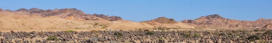
But first we had to find the entrance to this National Parque, which last year proved a very frustrating affair. And it was no better this time, with the SatNav system trying to send us the wrong way up one way streets time after time. In the end there was no alternative but to return to the hotel, follow our instincts and visual observations to drive to Santa Catarina, ignoring the requests from the electronic wizard to take a 300 km detour. The hills at the entrance to the Parque stand out from a great distance and so it was not really too difficult to find if you knew what you were looking for.

Last year we were frustrated by similar problems finding the entrance. Then we headed first for a Michel Lacoste location for Mammillaria plumosa, M. melanocentra and M. multiceps and ended up again frustrated as we got lost in a warren of tracks in small communities that seemed to block the way to where we wanted to explore. We were on a limited time budget, so once we had spent as much time as was wise, considering our other goals, we moved on without finding the spot.

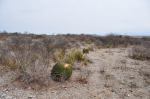
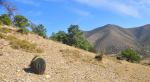
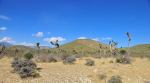
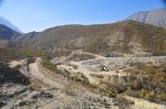
Today we had more time. It became immediately clear that the floods had done much damage here, but on the bright side for us, seemed to have erased many of the communities that had complicated life the previous year. We managed to park the car at a brand new radio mast station (?) unusually placed near the foot of a hill. A fence blocked our way to the hillside we wanted to explore, but some of the strands had already been persuaded to part so we managed to get in (and later out) without tears to clothes and our pride.

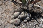
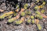
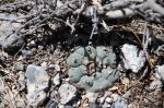
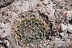
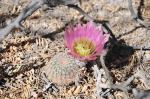
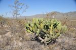
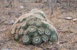
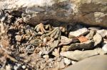
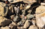
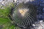
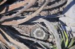
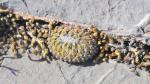
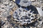
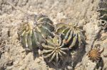
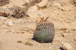
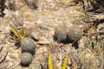
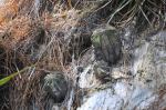
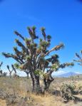
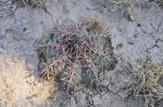
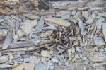
This was S2268. We had more time than in 2010, but still needed to be aware not to spend too long here. The first few meters were encauraging as we found lots of different cacti! Echinocereus adustus, E. viereckii, Neolloydia conoidia, Coryphantha sp. and two Mams that would fit the concept of M. multiceps and M. melanocentra that had been recorded before. Agave lechuguilla was scratching our legs and Acacia-like scrub was scratching at arms and legs. I set my mark to reach at some trees on a ridge near the top of the hill – well within the range of the coordinates on our GPS. Where were the M. plumosa? Another failed search? It was getting very hot on the hill and common sense dictates that you can not look forever for a plant that may no longer exist here. We started the journey back. Then, a tiny plant, slightly larger than my thumb nail caught my eye, growing in a crack on the goat track I had been following down. A closer look and sure enough – BINGO! How different this plant looked compared to the mounds filling up washing up bowls in Europe. Eunice had just walked past here. Was it worth coming back for a picture? I promised that she could have copies of mine if she wanted, but having seen it, I would not be surprised if she declined the offer. But at least another missed plant from the past had been laid to rest.

I decided to take a steeper route down the hill, often having to ease myself over the limestone rock face, putting hands and feet in narrow cracks (yes, not the thing I would advise others to do). As I put my hand down again I felt some fur and quickly pulled my hand back. Nothing moved. I took a look and found another, much larger M. plumosa – one that was well worth Eunice climbing the hill again. Great – mission accomplished – convincingly!

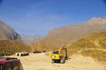
Before reading the next section, I urge you to point your browser to Google Search (or any other search engine that you fancy) and look up ‘Monterrey floods’ and ‘Huasteca floods’ and you will see the results of the rains in July 2010 that caused floods that made last year’s view of La Huasteca unrecognisable from the current pictures. The road and tracks we travelled on in 2010 were gone. There was much work in progress with workmen putting in pipes, drains and repairing cables.

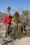
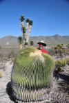
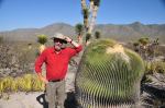
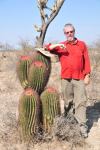
We found the location of last year’s stop where we found a number of large Agave victoria-reginae growing on the flat, but had to cross the river to get there. Not a great chalenge as temporary bridges crisscrossed the massive, mainly dry, river bed, so it just meant going back 100 m. to the last crossing.  Here (S2269) I found plenty of angles and set ups to try to improve on the amazing pictures from last year. I’m sure that at least one will appear in the work in progress ‘Prickly Pictures and Succulent Sights’ photo book that will show of my favourite pics from trips to the US, Mexico and Cuba. ‘Prickly Pictures vol. I will be out by September and contains pictures of just cacti taken during ten years of visits to South America.’

S2270 is where the road / track stopped. There was just a pipeline in a concrete housing that provided a way across the water, but only on foot. We spoke to a Mexican who had passed us earlier on an ATV (All Terrain Vehicle) who said that if we crossed on foot, we could get to the bottom of the huge dam, the Presa Rompepicos, where last year we had driven through a gate that was meant to control the water flow – but then there had been no water.

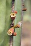
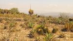
We pointed our zoom lenses towards the surrounding hill-sides and again found A. victoria reginae among the plants clinging onto the rocks alongside Hechtias.

All other images of the day of our drive through this northern part of La Huasteca have been filed as S2271 and do not contain any specific plant images – just scenery. 

Another great day!

Tomorrow we move onto Saltillo and will try to get into the southern end of the Canyon track, but we are prepared to find our attempts again frustrated by washed out roads.

I can thoroughly recommend Monterrey as a place from which you can explore the rich diversity of Mexican cactus and succulent plants, nature in general and spectacular scenery. Do rent a 4×4 car to see nature in its raw, wild and wonderful state and pamper yourself by staying at one of the many nice hotels in town. We stayed 3 nights at the Holiday Express Inn and can recommend it without hesitation.